Sunday, September 14, 2014

Epilogue

This was a wonderful trip — not the start of the Great Loop that we originally planned — but, a great trip never-the-less.  As Linda continues to explain to others: we set out for an adventure, and boy, did we have one — just not the one we were anticipating, which made it all the more fun to experience! Having the openness and flexibility to experience it as it came was a remarkable gift to each other. The scenery was beautiful, the people were personable, and the weather for the most part, was great. We learned much more about the United States and Canadian history during our revolutionary war and the war of 1812. With our companion — the brick —we learned more about church history as well. Of course, we became more knowledgable about our boat and boating; to include locks, bridges, navigation, trip planning considering tides, currents, wind, rain, distance, and fuel consumption. In addition, Linda proved that traveling with a “disability” is a not as hard as we initially thought. In her case, we just needed a little more attention to our meal planning. We completed the Triangle Loop. The Great Loop may be in our future — or not. We have so many adventures beckoning it is too early to tell what we will try next.

Saturday, September 13, 2014

Day 103: Chesapeake Bay Marina to Whitehouse Cove Marina, Poquoson, VA (39.3NM, 3.3 Hours)

Returning to Whitehouse Cove
in Poquoson, VA
We reviewed the weather and marine forecast for this morning, and for Friday the 12th (our 27th wedding anniversary date), and Saturday the 13th (a surprise homecoming dinner with Brian’s Mom, Ella). Once again, it was obvious that the forecasters weren’t certain what would happen today or the next three days based on the dramatic change in the forecast overnight. We couldn’t tell if the wind and waves were going to be moderate or bad, and if there was to be rain or not. We decided to depart and make our destination decision while underway. We found that the winds were greater than the forecasted 5-10mph and were from the south vice southwest. Hence, the waves we encountered were greater than 1-2 feet. We decided to press for Poquoson, VA and spend our
Brian & his Mom, Ella
anniversary in our local area. After three and one half months of cruising, neither of us felt we were being short rifted. Brian even tossed in a promise for another spa date for the both of us, then cancelled our reservations with the Tides Inn, worked with Craig Brown, dock master and at Whitehouse Cove Marina, for a slip, made dinner reservations with Fins in Newport News for our anniversary dinner, and turned off our AIS so Brian’s mom couldn’t track us returning so soon. She has been following us through her desk top computer the entire trip and learning about the local areas we have passed through. Nick greeted us when we arrived, helped us tie up, and transported us home for a quite celebration. In fact, Nick volunteered to be our chauffeur as we celebrated our anniversary. Both our sons had prearranged a dinner date with their grandmother for the evening of the 13th to enable our surprise return. They picked her up in one vehicle, while we traveled to the restaurant in another. The look of astonishment when she arrived at our table was priceless, and worth the added effort to pull it off. Our sincere thanks to Chris and Nick, and the wonderful hostess and staff at Carrabba’s in Newport News, Va.

Wednesday, September 10, 2014

Day 102: Onancock Town Warf and Marina to Chesapeake Boat Basin, Kilmarnock, VA (30NM, 2.4 Hours)

Historic Christ Church,
Weems, VA

Interior of Christ Church

Christ Church 3-Tiered
Pulpit

Linda & the Brick at the
Historic Christ Church
Up for an early start today…with lines released at 06:24am for our 20 minute ride out Onancock Creek to the Chesapeake Bay, anticipating a two hour ride across to the western shore.  The creek was smooth and very little breeze could be felt.   However, we knew from the marine weather forecast from the internet and VHF marine radio that the wind would be 5-10 knots from the north and waves would be 2-4 feet on the bay — no sweat.  We naturally couldn’t see the western shore, but a nearly full moon was plainly visible and was in the perfect spot to lead us in the direction we wanted to go.  Even though we had our route on the chart plotter navigation, the moon made a wonderful navigational marker in the sky.  Again we throttled up to keep our bow high.  Yet, the voyage was smoother than expected and in just over two hours we had traversed Fleets Bay and were in Indian Creek idling up to the Chesapeake Boat Basin.  Linda called and spoke to George who was gracious enough to accept us with only 20 minutes notice.  We docked and registered and took some time to relax.  At 11:00am we checked out the courtesy van.  We headed
Brian & the Brick at
Grace Church, Kilmarnock
for the recommended burger place, but were pulled to the Smoking Joe’s BBQ that had a plethora of gluten free options for lunch.  It has been a long time since Linda has been able to eat BBQ.  Afterwards, we visited Grace Episcopal Church in Kilmarnock and the Historic Christ Church in Weems for some pictures.  The museum at the Historic Christ Church was open, and we took a brief tour of the museum and the 1735 church that is in pristine colonial condition.  The church is under the care of the Foundation for Historic Christ Church that is made up of members from Grace Episcopal Church, Kilmarnock.  Unfortunately, we had to cut our visit short because our two hours with the car was up and we needed to get back.  The value of having a courtesy car is precious to us, and other boaters.   Tomorrow we will head to Urbanna and Irvington sometime in the morning.  No rush.

Tuesday, September 9, 2014

Day 101: Onancock, VA

Holy Trinity Episcopal Church

Linda & the Brick inside Holy
Trinity Episcopal Church
We awoke to light rain this morning and stayed awake during the light rain all morning.  Once the rain left around 2:00pm, we went for a walk to see the town.  We visited Holy Trinity Episcopal
Sunset on the Onancock Creek
Church
for some pictures then strolled to The Blarney Stone Pub for a light lunch.  Afterward we headed back to the boat and did a light load of laundry.  Brian also made some calls to arrange our slip and a dinner at The Tides Inn for our twenty-seventh wedding anniversary this Friday.

Monday, September 8, 2014

Day 100: Onancock, VA

It hadn’t started raining when we first got up this morning. So we took the opportunity to get a ride into town to get some groceries. It was a very slow morning for the marina.  Charles, the dockmaster, was more than happy to take us the two miles to the store since no boats were expected to arrive or depart due to the bad weather on the Chesapeake Bay.  When we returned, in a downpour of course, Brain stepped over and invited the crews of Lorie Lynn and Sea Pearl, the only other transient boats at the marina, for docktails at 5:30pm.  The rest of the day, we sheltered on the boat listening to the rain, reading and watching Netflex.  The crew of Sea Pearl couldn’t make it to docktails unfortunately.  But, the crew of Lorie Lynn, Lorie and Dr. Ivor Van Heerden, and their guest crew members Rick Knight and Miriam Little made it.  Ivor is originally from South Africa, has a doctorate in marine sciences, and was deputy director of the Louisiana State University (LSU) Hurricane Center.  Lorie is from the United States, and Rick and Miriam are from Scotland.  Both Ivor and Lorie are avid sailors having crossed the Atlantic and Caribbean several times by sail.  They met Rick and Miriam on a voyage to Scotland.  Both Rick and Miriam flew to the United States for a sail cruise on the Chesapeake Bay.  We had a great time talking of recent trips, the weather, the pending Scottish vote for independence (18 Sept 2014), and the sailboat Ivor modified for ‘blue water’ sailing.  Shortly after our guests left, we were relaxing when we heard a thump on the forward hull.  Dashing out in the rain at night, we looked for items in the water.  We didn’t see anything.  We check the lines and cleats thinking that a line might be too taught and pulled a cleat out.  Everything was normal.  However, we did notice the water level of the creek was nearly over the marina’s bulkhead.  Some docks were completely covered with water.  Looks like tomorrow will be another day like today.

Sunday, September 7, 2014

Day 99: Somers Cove Marina to Onancock Town Wharf and Marina, Onancock, VA (23.6NM, 3.0 Hours)

Onancock Wharf & Marina
The rain continued this morning until around 8:00am.  Yet, the wind continued to blow from the northeast at 10-15MPH with higher gusts (small craft warnings were in effect for waves 3-5 feet and higher).  Currents on the Chesapeake Bay were flowing south. So, we said to ourselves, “What, me worry?” and decided to make a run for Onancock (pronounced Nancock).  We topped off with fuel then headed out not far behind another trawler heading north.  Once we passed the no wake zone buoy we
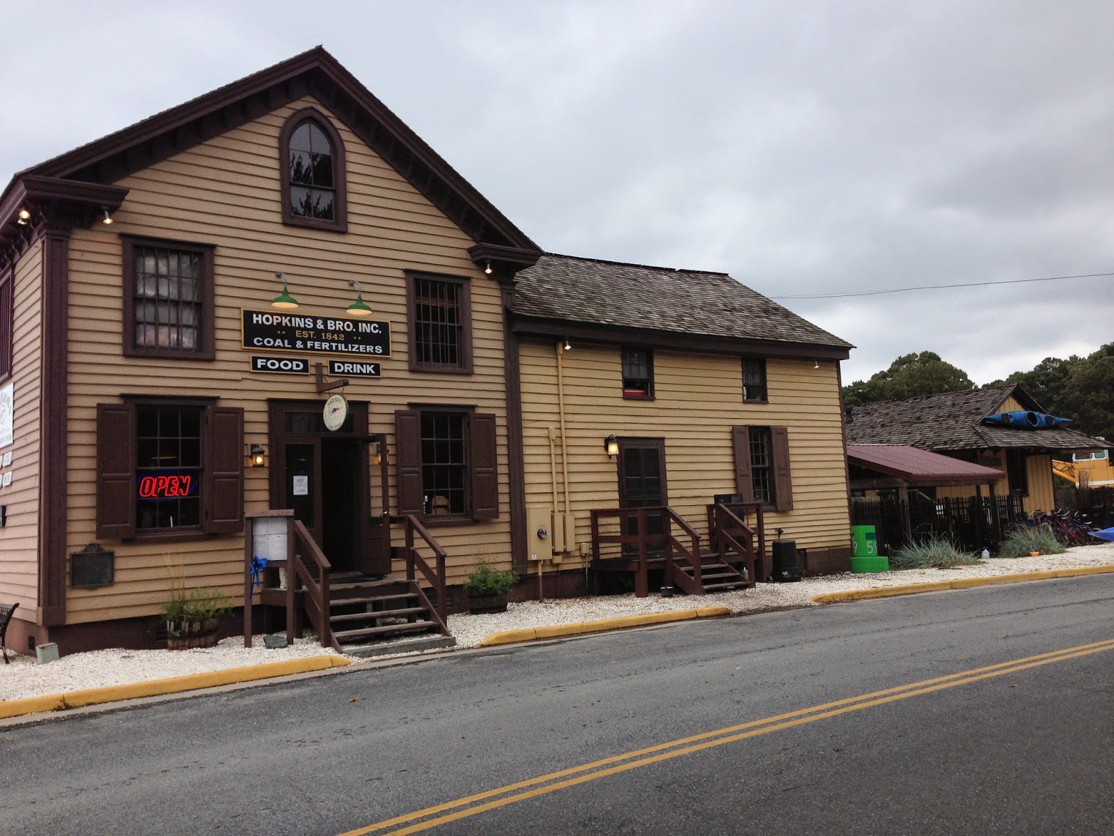
Exterior of Mallards: Formerly
Hopkins & Bros. 

Inside Mallards: Old mercantile
counter

Inside Mallard's: Steamboat
ticket window
trotted up to 18,000 RPM (10 - 14 knots depending on whether we are climbing a wave or sliding down the other side).  All-in-all it was a great ride for us.  But the trawler that preceded us out radioed back to Somer’s Cove Marina that they were returning.  We had the advantage actually of being able to run close to marshes and the shallow waters of Great Fox Island, Little Fox Island, and Watts Island to try to reduce the size of the waves we’d experience as we headed south.  We also had the current with us.  Once we got into the protection of the Onancock Creek everything went quiet.  It was like night and day.  The water was smooth.  The wind was light.  We idled up the creek and enjoyed the views.  After docking and checking in at the Onancock Wharf and Marina, we had lunch at Mallards At The Wharf restaurant next door.  It
Sunset on Onancock Creek
was so pleasant, we elected to eat outside and were joined by many others shortly after.   Hopkins & Bros. was founded in 1842 as a waterfront store, warehouse, shipping business, steamboat ticket office, and occasionally a bank.  Some Marylanders were sympathetic to the Confederacy at the start of the Civil War and the owner Steven Hopkins had to take an oath of allegiance to the United States to continue operations.  Although the location of the 1842 building has moved and the outbuildings have been removed, the business operated until 1965.  The remaining buildings and all of the business records were donated to the Virginia Historical Society (VHS), Eastern Shore.   The building has been leased from the VHS and has operated as Mallards since 2010.  We gave Splash Down a well deserved washing when we got back from lunch.  Then we walked the town and had dinner at the Charlotte Hotel and Restaurant.  They had great gluten-free food options.  Returning to the boat, we looked at the weather and decided to stay put for a day or two and not beat ourselves up trying to get to the western shore.   There is much more exploring to do in Onancock.

Saturday, September 6, 2014

Day 98: Smith Island Marina to Somers Cove Marina, Crisfield, MD (10NM, 1.3 Hours)

Again the winds were strong from the south-east.  The channel to the east of Smith Island is approximately four nautical miles long.  Brian went slowly noting PVC poles have been added to mark shoaling in the channel.  Once exiting the channel and the protection of Smith Island from the 2-4 foot waves coming up the Chesapeake Bay, we throttled up and made a run for Crisfield.  Not much has changed in Crisfield’s harbor since we were here a few years ago with the Hampton Yacht Club.  It was much too hot and humid to stroll the town; we opted to stay cool on the boat.  Later as the sun set, we walked over to dine at the restaurant we enjoyed the last time we were here - the Crisfield Crabhouse Grill and Tiki Bar.  We viewed a beautiful sunset as we enjoyed our meal on the outdoor porch.  Late night, the storms hit with thunder, lightening and lots of rain.

Friday, September 5, 2014

Day 97: Slaughter Creek Marina to Smith Island Marina, Ewell, MD (44NM, 5.3 Hours)

Sunrise over Little Choptank River

Sunset over Smith Island
Today’s marine forecast was for south-east winds at 5-10 mpg, with higher gusts, and waves from 2-4 feet. We got up early for a twilight departure.  Brian followed the same course out as when we arrived going very slowly.  The first half of the voyage was fine with light winds.  But, as the sun rose higher, the wind and waves picked up as well.  We throttled up
Smith Island Cake
from 8 knots to 15 knots to minimize the rolling and yawing.  Once we were in the protection of Smith Island we dropped back to idle and followed the channel into Ewell and Smith Island Marina.  Once tied up, we went to lunch at Ruke’s Grill.  It was the only restaurant open since tourist season is over and the watermen business is down.  Brian tried the Maryland State Cake for dessert - the Smith Island Cake. After lunch Linda took some photos around the heart of the town.  Brian checked the engines.  There was not much else to do but watch the Deadrise boats with oysters pass by to unload their catch further up the channel.  Tomorrow we have a short run to Crisfield, MD.

Thursday, September 4, 2014

Day 96: Cambridge Municipal Marina to Slaughter Creek Marina, Taylor’s Island, MD (24NM, 3.3 Hours)

Linda using Ped-O-Pilot
It was another beautiful day to be on the water.  The Chesapeake Bay was calm enough Linda could use the ped-o-pilot.  She drove most of the voyage this way (that would be with her feet).  Brian turned off the ped-o-pilot when we approached the channel for Slaughter Creek.  The Slaughter Creek Marina dock master had given us instructions on how to navigate the channel yesterday.
“Stay close to Green Daymarks 3 and 5.  At Green 5, turn 90 degrees to Green 7.  Pass Green 7 three feet on the wrong side and head for the center between Red 8 and Green 9.  After marks 8 & 9, proceed to the marina”.  
After all that we hailed the marina on radio and called their phone number, but there was no answer.  We took the first T-head.  The dock master arrived as we were setting our lines.  He had been mowing the grass.  While checking in at the marina office some
Interior of Palm Beach Willie's

Exterior of Palm Beach Willie's

The barge as it appeared in ABC/
Warner Bros. TV show Surfside 6
watermen came in after unloading their boat of crab-pots and loading them on a truck.  I remarked that there was a very noticeable lack of crab-pot buoys in the bay.  One of them said that there is a parasite that is affecting the blue crab all over the Chesapeake Bay.  After checking in, we did chores.  We went to Palm Beach Willies Tiki-Bar for dinner after chores for their special — prime rib.  Palm Beach Willie’s is a barge nestled between land and a pier for outdoor dining.  The two story barge was once a set for an ABC television show called “Surfside 6” that aired from 1960-1962.  It was about young ‘hot body’ detectives in Miami Florida.  The United States Coast Guard purchased the barge from the production company after the show was canceled and moved it from Miami to its current location to be a training facility. A few years ago the Coast Guard sold the barge to the current owners.  The building was remodeled into a restaurant and named for the owner’s dog.  This place is popular with the locals.  The prime rib was excellent.

Wednesday, September 3, 2014

Day 95: Knapps Narrows Marina to Cambridge Municipal Marina, Cambridge, MD (16NM, 3.1 Hours)

Skipjack Rebecca T. Ruark
Before leaving Knapps Narrows and Tilghman Island, we borrowed the marina’s courtesy car to go see the oldest working Skipjack on the Chesapeake Bay - the Rebecca T Ruark.  The Ruark was built in 1868. The Ruark splits it time oystering and sailing charters.  Unfortunately, we could not find anyone around to talk to about the boat. So, we left and drove to the very southern end of the island called Black Walnut Point; turning round in a parking lot of the Black Walnut Inn.  Enroute we passed marshland with tall grasses that harbored large black flies that were attracted to the car.  Linda wanted to stop and take
St. John's Chapel - 1891
United Methodist
Tilghman Island, MD
pictures of a small chapel on the side of the road, but we had to settle for taking photos through the window that wasn’t covered by a flys.  We prepared for departure after returning the car.  We did a brief stop at the marina’s fuel dock.  From there Brian hailed the Knapps Narrows bridge on the radio and requested passage.  It was a smooth short ride to the Cambridge Municipal Marina.  The dock master at Cambridge asked if we were staying for the upcoming Marine Trawler
Christ Church (Episcopal)
Cambridge, MD
Owners Association (MTOA)
rendezvous September 9 - 11.  We told him we were aware of the rendezvous, but had plans to visit other places along the Eastern Shore instead.  We walked into town, took some photos, then had linner  (lunch/dinner)  at Snappers Waterfront Cafe.  Our waiter, Gary, was wonderful.  He worked with the chef to get Linda gluten-free crab cakes.  We enjoyed the rest of the afternoon & evening on Splash Down’s lanai.


Tuesday, September 2, 2014

Day 94: St Michaels Harbor Marina to Knapps Narrows Marina & Inn, Tilghman Island, MD (18NM, 2.3 Hours)

Knapps Narrows looking East.
Tilghman Island on right.

Knapps Narrows looking West.
It was a nice slow morning.  There was no rush since it was only a two and a half hour ride to Knapps Narrows - a navigable channel separating the mainland eastern shore and Tilghman Island.  Plus the wind and current were in our favor.  Brian took the complementary ride back over to the Acme Market for some additional provisions while Linda cleaned the cabins.  The waters were just as we hoped and made for a very enjoyable ride.  After checking in at the Knapps Narrows Marina & Inn, we made a beeline across the Knapps Narrows Bascule Bridge to Characters Bridge Restaurant for lunch.  It was very hot and humid — we were discouraged from doing any touristy stuff this afternoon.  So, we walked back to the boat and relaxed for the rest of the evening - Linda with her latest book and Brian and his electronic media.  We’ll do the touristy thing tomorrow morning since we have a short run to our next destination at Cambridge, MD.

Monday, September 1, 2014

Day 93: St Michael’s Harbor Inn & Resort, St Michael’s, MD

The Brick & Brian at
Christ Church, St. Michael's

Interior of Christ Church
We took advantage of the complementary breakfast this morning. The room came with complementary air conditioning, too, which it was fortunate since it was a hot and humid morning.  But, it all came to an end when we ventured out to play tourist in the historic area of St. Michaels.  We took a complementary air conditioned ride to Christ Church; a beautiful Episcopal Church in the downtown area.  After a walk around the church grounds, we checked out The Christmas Store and the Acme grocery
View of Splash Down at the
St. Michael's Inn & Marina from the
Crab & Steak House Restaurant
market.  Then called for the air conditioned ride back to the Inn to make our spa appointment.  Ahhhhh.  Most excellent and relaxing massage.  Just what we needed.  Plus, the wine and beer we had afterward helped, too.  Later that evening we took the complementary air conditioned ride to the Crab and Steak House Restaurant for dinner.  It was cool enough to walk back through the neighborhood of circa 1850 homes.

Sunday, August 31, 2014

Day 92: Chester River Yacht Club to St. Micheal’s Harbor Inn & Restort, St. Michael’s, MD (32NM, 5 Hours)

We left this morning with the current and wind (10-15 knots with gusts) against us.  In fact, it was a very nice ride.  It was choppy, but for the most part the waves were head on.  We arrived at the Kent Narrows Bascule Bridge (which opens on the hour and half hours) right on time for it to open.  There was some confusion when a sailboat named “Splash Landing” attempted to call the bridge.  Brian thought the bridge was calling us since many bridge tenders get our boat name incorrect.  Once passed Kent Narrows, we were in Prospect Bay.  There were many more boats, especially sail, than in the
St. Michael's Harbor entrance from the Miles River
Chester River and before the Kent Narrows.  At one point we had to weave in and out of sail boats making for the greater Chesapeake Bay.  When we, arrived St. Michael’s Harbor Inn, the dock master wanted to go inside a dock enclosure to dock stern in to slip B6.  Brian barely slipped between to boats tied up on either side of the narrow channel then rotated Splash Down for a stern in docking.  But, just before he had Splash Down’s stern into the slip a strong gust put our swim platform in danger of hitting a piling.  Brian, unable to recover due to the narrowness of the fairway decided to abort the docking in the enclosure, exit the enclosure, and wait for a dock wall outside the enclosure to open up in 20 minutes.  We hovered in the channel for 30 minutes then moved into easily onto the dock wall.  We were able to find our way into the inside (air conditioned) bar for lunch and to arrange for our spa appointments for tomorrow afternoon — with great expectations!

Saturday, August 30, 2014

Day 91: Mear’s Point Marina to Chester River Yacht & Country Club, Chestertown, MD (23NM, 4.25 Hours)

Pride of Baltimore at Chestertown
Docks
It was a beautiful day to be on the water.  We expected it to be rougher waters according to the forecast, but we guess the weather didn’t look at the forecast and did what it wanted to do.  The Chester River has a wide mouth, but narrows quickly as it meanders northeast into the Maryland peninsula.  We cruised past
Emmanuel Church, Chester Parish
Established 1706
the Chester River Yacht Club to Chestertown’s docks observing some of the tall ships that were in port.  One was the Pride of Baltimore and the other was the Sultana.  We called the Chester River Yacht Club Dockmaster in route back toward the Chester River Yacht Club to get our slip assignment or T-head.  Unbeknownst to us he was not in town so he was not in a position to give us realtime information. He told us to dock behind a 50-footer on the B-dock.  We informed him there was already a boat there.  So, he gave us the option to dock in slip B-10 or at the A-dock T-head.  Since slip B-10 only had a quarter-pier we chose the A-dock T-head.  A pontoon boat moved for us as we approached the A-dock.  We got all tide up when the dock master called to informed us that there is a 60-footer due in and will use the A-Dock.  Bottom line,
Some older homes in Chestertown

Architectural detail
we ended up docking in slip B-10.  We had a glass of wine to smooth over our frustration with the dock master then walked to the Pro-Shop to check in.  Then we walked about a two miles into Chestertown.  We expected more character based on the write-ups.  Yes, there were a few historic buildings, but every town has a few historic buildings. After walking around a bit, we headed to the town docks and ended up at the Fish Whistle Restaurant for a drink and chicken wings,  then walked back to Splash Down stopping at the club’s bar before actually getting on the boat.  All in all, we decided you have to be determined to come to Chestertown.
Vultures watching as we walk
back to the boat

Friday, August 29, 2014

Day 90: Rock Hall Landing Marina to Mear’s Point Marina, Kent Narrows, MD (10.7 NM, 1.5 Hours)

Slower start for today after understanding we could not get into any marina in Chestertown, MD — well, it is Labor Day weekend!  So we decided to stage at Kent Narrows for a run up the Chester River tomorrow.  An easy departure from Rock Hall and a short ride had us into the marina at Kent Narrows at 12:30.  After a quick pump out, we were secured in our slip in no time.  After fixing a few lines and such, we checked in (they had all our details from when we visited with Hampton Yacht Club group in 2012) and on to Red Eyes Tiki Bar, for a celebratory drink (or two) where we met a couple from McLean, Virginia, that are visit several microbreweries and tiki bars (by car) in the area.   They gave Brian a few ideas for St Michaels, which we will may upon.  Upon feeling very relaxed, we headed to the boat for a few chores, rest, and dinner.

Thursday, August 28, 2014

Day 89: Chesapeake Inn & Marina to Rock Hall Landing Marina, Rock Hall, MD (40.5NM, 4.75 Hours)

The Bayard House (far right).
Considered to be the oldest building
in Chesapeake City - Circa 1780
This morning we strolled about the shops and homes near the marina.  Some were well maintained homes from circa 1820’s.  We returned to the boat and prepared to get underway.  The currents will be against us part until about noon and we didn’t want to get into Rock Hall after the marina closed. Therefore, we split the voyage so the current would be against us half way and with us the rest.  Brian pulled our lines at about 10:15am and Linda took us into the canal.  By 10:45am we had exited the
Circa 1800 Homes
Chesapeake and Delaware Canal and were in the Elk River.  The mouth of the Elk River opens into the Northern Chesapeake Bay.  The Susquehanna River also opens into the Chesapeake Bay from the West with a peninsula called Elk Neck separating the two rivers.  The wind was blowing from the Northwest down the Susquehanna River giving the water a nice long fetch.  As soon as we passed the point of Elk Neck the water got rough.  For about fifteen minutes we had large waves coming on our stern quarter.  Linda sped up to better control Splash Down.  But, as sudden as the action started the waves settled down and Linda trotted back to our leisurely cruising speed.  We switched drivers when we had Rock Hall in sight.  The waterway guides warn about the shallowness of the Swan Point Bar that runs north to south outside of Rock Hall.  We had to run south of Swan Point about 3.5 nautical miles before rounding bar and heading back north to Rock Hall.  The charts showed we should have six to nine foot depths out side the bar; but that was not the case.  Brian made straight for deeper water when the chart plotter showed we had less than three feet.  The shallow waters and the placement of the red and green buoys reminded us of the navigation of the channel to get to Cape Charles.  We were tied up at  3:00pm.  After checking-in and having another “blinner" at a nearby restaurant, we walked into town.  Believe it or not, there is a West Marine store within walking distance of a marina. (It seems there is never a West Marine store close by when you need one.  We didn’t need one so this was close by.  For some reason, the West Marine stores are “in town” and not near marinas — it is  a puzzlement).   We got a few items there, got a few provisions from the liquor store near by, then called the Osprey Flyer Tram for a ride back to the marina.  The tram only cost a dollar per rider.  The gentleman took us on a little tour of Rock Hall and regaled us with stories — true or not — about the area.  It was a fun and short ride.  Once back on the boat, we gave Splash Down a well deserved bath and observed a gorgeous sunset.

Wednesday, August 27, 2014

Day 88: Farley State Marina, Atlantic City to Chesapeake Inn & Marina,Chesapeake City, MD (91NM, 8.5 hours)

Sunrise over the Atlantic
Ocean (6:28am EST)
Today was the best day, per Brian’s forecasting, to be in the outside of the Atlantic and cross the large Delaware Bay.  During the remainder of the week, conditions would rapidly deteriorate due to Hurricane Cristobol.  We didn’t want to delay our return to home waters, so we decided to get into the Chesapeake and Delaware Canal and afterwards consider options depending on how tired and how difficult the crossings were.  Winds were less than five knots, currents were running south along the New Jersey coast and north up the Delaware Bay.  We left at 5:40am; Linda at the helm for her first time navigating out of a slip.  She did great.  At 6:22am we had a beautiful sunrise.  The waves were two to four feet with an occasional six foot wave.  The period betweens waves Brian estimates was about 8 - 10 seconds
Delaware Bay's
Miah Maull Shoal Light
(You can see the wake of
the current on left side
of the light)
(Linda doesn’t like rough seas), then we slowed upon entering Cape May, switched rivers, and ran 6 - 9 knots through the Cape May channel.  In route we saw the back side of what looked like huge breakers along the New Jersey coast. We learned later that all along the New Jersey coast rip current warnings had been posted due to Cristobol.  From where we were, the waves were not bad at all. We averaged about 10 knots up the Delaware Bay with an additional push from the currents.  The winds were so light they were not a factor.  We also saw two pods of dolphins.  One was in the Atlantic and the other was at the western end of the Cape May Canal.  All-in-all, this crossing was a great ride. We briefly stopped at Delaware City Marina to top off the tanks thinking we may have drained them by Linda’s hot run.  We had much better than expected fuel economy.  Yea!   We took on enough fuel to get the volume discount.  Delaware doesn’t have sales tax, so we really scored on this stop.  We were happy the owner and dockhands remembered us from our stop in June.  Although they sorely tempted us regarding a new restaurant which just opened, we wanted to be done for the day, so thanked
Chesapeake Inn & Marina
them and pressed on.  We entered the Chesapeake and Delaware Canal in time to catch the westward current to Chesapeake Bay.  We gained an additional 2+ knots from the push.  Brian’s getting this navigation stuff down really well.  We arrived around 2:15pm, checked in, and headed straight to the Chesapeake Inn Restaurant (written up in the Wade’s book of “Crab Decks and Tiki Bars”) for wine, beer, and even a gluten-free meal for Linda.  We called this meal our “blinner” as it was breakfast, lunch and dinner in one.  After returning to the boat, we listened to the live band at the Tiki bar.  All in all, a good day with the added plus of being back in “our” own  familiar Chesapeake waters.

Tuesday, August 26, 2014

Day 87: Farley State Marina

Today was another day of chores.  Linda did laundry and Brian fixed items that had been on our list for a while as we mentally prepared to “go outside” in the ocean.  A pleasant slow day.  We spent a bit of time planning routes and controls for our 5:30 am departure tomorrow, including alternative stopping points if the waves were too rough.  Once we pass Ocean City, there isn’t a real alternative to getting into Cape May.  However, if we arrive at Cape May and feel we have the energy, we may push to arrive at the C&D Canal before the winds shift in the early afternoon — a simple situation of what is forecasted versus what actually occurs, and when.  We can’t second guess the later, so we will be patient, but prepared.  Brian grilled on the back of the boat and we enjoyed a quiet dinner aboard.

Monday, August 25, 2014

Day 86: High Bar Harbor Yacht Club to Farley State Marina, Atlantic City, NJ (56NM, 3.75 Hours)

Brian’s travel plans had us leaving just after 8:00 am and again sprinting toward Atlantic City to get through the channels before low tide.  He also included time for “No Wake” areas and going slow in areas where shoaling was reported.  Comments left in Active Captain this year reported shoaling and boats being grounded on those shoals.  One comment said a TowBoatUs operator recommended
Homes in the Borough of Beach
Haven, Long Beach Island
hugging the green markers.  We did what was recommended in those areas and had over 2 feet under our keel.  In route, we passed under the only causeway linking Long Beach Island to the mainland.  From there we could see the skyscrapers of Atlantic City.  Then the channel took us in close to the northern part of the island.  The homes had docks right on the channel.  Others homes were congregated around man-made canals like what is found in North Carolina and Florida.  Passing from the populated apart of the island into the tidal flats we were invited by New Jersey’s unofficial state biting bug; the Greenhead Fly.  They are attracted to dark objects like our canopy on the flybridge.  There were hundreds of them inside the canopy with at least 10 to 20 of them
Atlantic City seen from the causeway. 
buzzing around our heads and biting our legs.  We couldn’t go fast due to the areas of shoaling we needed to avoid.  We arrived in Abescon Bay inside of the Abescon Inlet well before low tide.  As soon as left the channel we opened up the throttles, and with a flyswatter, shooed or killed the flies.  Arriving at Farley State Marina we took on fuel before docking in our assigned slip.  We immediately checked in and went to the outside bar for lunch.  After lunch, Linda cleaned the flybridge and lanai of fly carcasses, and inside of Splash Down while Brian washed down the boat.  Too tired to cook dinner, we had dinner at Vic & Anthony’s Steakhouse.


Sunday, August 24, 2014

Day 85: Hoffman’s Marina to High Bar Harbor Yacht Club, Barnegat Light, NJ (26 NM, 2.5 Hours)

Point Pleasant Canal
Brian worked out the tide and current data for our departure and arrivals since, according to local knowledge, the inter-coastal channels near then Manasquan and Barnegat Inlets are dramatically affected by the tidal currents. We had to arrive Barnegat Inlet area before Max Ebb and low tide, which was about six hours after Manasquan Inlet’s high tide. If we ran at our economical speed, we’d arrive in the Barneget Inlet six hours later — not good. However, running at 15 knots or over, we’d arrive at Barneget Inlet at Slack Tide reducing the possibility of running aground in the notoriously shallow New Jersey Inter-Coastal Waterway. Leaving Manasquan just after high tide we had to pass through the two mile long, 50 foot wide, Point Pleasant Canal. Before entering the canal we were doing about six knots. In the canal our speed shot up to eleven knots from the current. The water looked like rapids. We’d hate to try to negotiate this channel during Max Flood or Max Ebb. The rest of
Barnegat
Lighthouse
the voyage was uneventful and enjoyable despite keeping a close eye on the markers and the sonar. We arrived at High Bar Harbor Yacht Club at 10:10am. It was Slack Tide. This gave us over a foot of water over what could be expected at Low Tide. We
St. Peters at the Light

Linda & the Brick in front
of the Parish Hall
learned that High Bar Harbor is a marina; not a yacht club, but a very nice marina. As we walked toward the marina’s office we noticed a boat from Virginia Beach. Bob and Betty Campbell came over to Splash Down to welcome us to their marina (with a wonderful bottle of wine). After Bob and Betty left, we walked up to the road in front of the marina to catch Long Beach Island free shuttle that services the 18 mile long island called Long Beach. Long Beach has seven boroughs; Barnegat Light, Harvey Cedars, Surf City, Ship Bottom, Beach Haven, High Bar Harbor, and Hogate. We were not told, nor is it in Long Beach Island Shuttle’s map, that there is a north bound and south bound shuttle, AND only the South bound shuttle picks up at the marina. When we got on the shuttle, we did not know we’d be on the bus for two hours to get to the Barnegat Lighthouse park at the North end of the island. It would have taken us less than 30 minutes if we walked. Never-the-less, we learned more about the island from the shuttle driver. The six boroughs remain independent honoring their original charters. The larger of the six boroughs on the island provide police and fire services to the smaller boroughs. She rumored that Jon Bon Jovi has a house and that Ernest Hemingway once owned a home there. Neither of which Brian could verify independently. It was nice to stretch our legs once we finally arrived at the lighthouse park. The Barnegat Lighthouse was designed by Lt. George G. Meade in 1855. Lt. Meade would later become famous as General Meade during the civil war. The light is the second tallest lighthouse in the United States at 165 feet. It operated as a first-class navigational aid from 1859 to 1927, and a second-class navigational aid until 1944. Brian climbed its 217 steps for some photos. We walked back to Splash Down. One the way we passed by a liquor store for some provisions and took some photos with “the brick” at St. Peter’s-At-The-Light Episcopal Church. It was a 30-minute walk to get back. Tomorrow we’ll head for Atlantic City.

Saturday, August 23, 2014

Day 84: Hoffman’s Marina & Manasquan, NJ

Entering Manasquan

Glimmer Glass Bascule Bridge
Great day to relax and recover from yesterday’s harrowing journey.  We walked to the beach and along the jetty to review what we had not taken in, being so focused on powering through the rough seas.  We noticed a few boats out, bouncing along like we did yesterday and were thankful to not be out in the surf.  These are hearty fisherman to go out in this mess.  Linda had done a quick search on the history and regaled Brian with some snippets as we walked, like how the early settlers in the 1600s were Dutch, and the town name — Brielle, is in reference to a town of the same name in the Netherlands.  Most of the area focused on ship building — just like back home.  We crossed over an old bascule bridge that spans the Glimmer Glass inlet to the Manasquan River.  This bridge is on the National National Register of History Places.  It is a bascule bridge using
Beach-front homes facing the
Atlantic Ocean

Manasquan Inlet
cables and rolling counterweights to lift the road.  Built in 1898 (with slight modifications the 1950’s), it is the only bridge of this type left in New Jersey.   Upon returning to the marina area, we lunched at the newly opened (only three days old) Sand Bar Restaurant.  We were offered a table upstairs and had the place to ourselves.  I doubt that will last long as the place gets more popular by the day.  We followed up with a stroll along the docks looking at other boats in the marina, and then returned to Splash Down.  Tomorrow, we’ll head down the New Jersey Inter-coastal Waterway since the wind and sea state in the Atlantic is not conducive for travel.